You design the future. We help you make it happen.
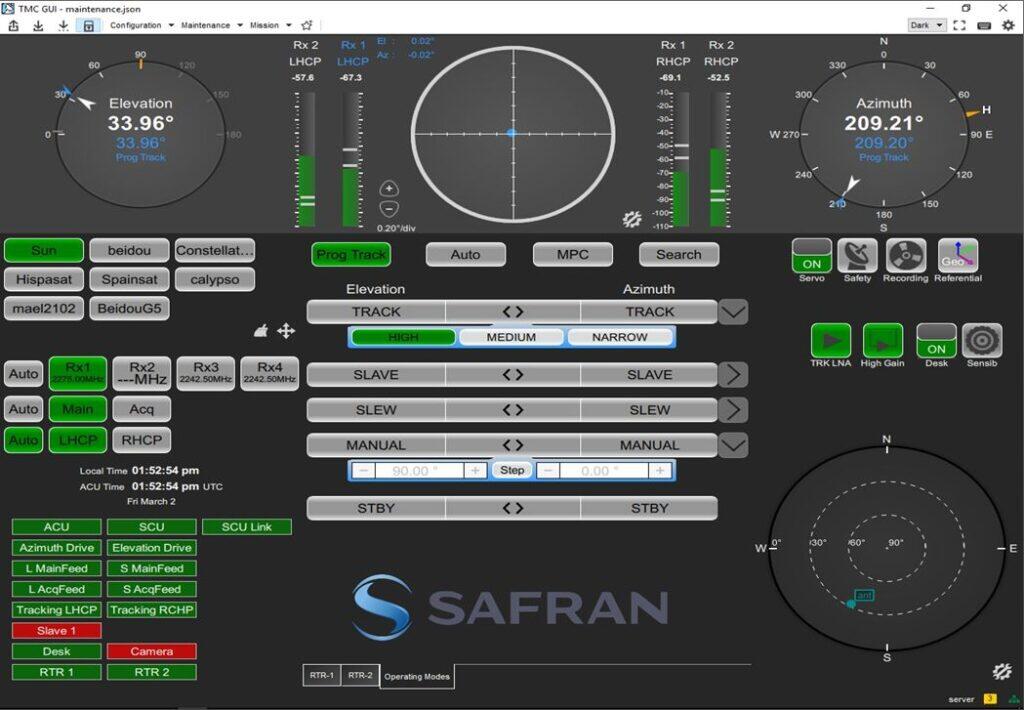
Safran DSI - TM MAESTRO Telemetry Mission Controller
- Global Telemetry Control: One Solution for the global Telemetry Control: Antennas, Receivers, Recorders, Boresights…
- User-Customizable GUI: Build your own User Interface, thanks to Sizeable Widgets and Multi-Session Screens
- Multi-Station Control: Control of Multiple Stations from a Single Place, Extending the Range Covered by the Mission
- Scalable & Evolutive: Any new equipment can be added to the System
- Remote Station: Take Control of a Far-Off Station without the Need to Travel, including for a Shipborne Station
TM MAESTRO provides a comprehensive and centralized solution for monitoring and controlling telemetry infrastructure worldwide.
Designed to meet the critical needs of telemetry operators, this software offers a user-configurable GUI that adapts to various user profiles and mission phases, from preparation to live flight tests and station maintenance.
TM MAESTRO is scalable and easily accommodates new telemetry equipment, allowing for the addition of an unlimited number of components, from antennas, receivers, recorders, to decommutators, making it a highly flexible system.
More Product Information
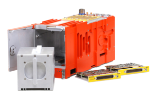
- Compact Design: Ideal for mini and micro satellites
- Long Lifetime: 7 year-lifetime in Low Earth Orbit missions
- COTS Design: Radiation tested and hardened, ITAR free
- Dual, Quad and Recording Option: Full Flexibility of Configurations, including full band visibility and optinal RF recording
- CH. 10 & IRIG218-20 Output: Easy and Modern UDP Data Spreading
- DQM/DQE: Embedded Data Quality Metrics / Encapsulation comptible with Best Source Selector
- 8.4" Screen: Intuitive GUI, Keyboard and touchpad for Full and Easy Direct Control
- EQ+: Adaptive Equalizer for all Modulations, on Video and PCM outputs
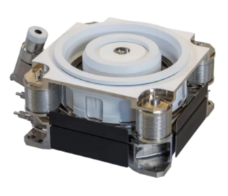
- Best-in-Class Servo Controls: User Selectable Servo Controls
- Time Proven: Robust Pedestal in Operations at Test Sites for Decades
- Transportable Adaption Kit: Skid, Container or Trailer-Mounted Versions
- SCM 1000 Hz Scan Rate: Common Design for Main & ACQ-AID Feed
- Modular L, S or C Band: Simple Add-On Upgrade without any Structural Change

- Global Telemetry Control: One Solution for the global Telemetry Control: Antennas, Receivers, Recorders, Boresights…
- User-Customizable GUI: Build your own User Interface, thanks to Sizeable Widgets and Multi-Session Screens
- Multi-Station Control: Control of Multiple Stations from a Single Place, Extending the Range Covered by the Mission
- Scalable & Evolutive: Any new equipment can be added to the System
- Remote Station: Take Control of a Far-Off Station without the Need to Travel, including for a Shipborne Station
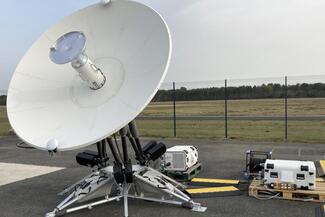
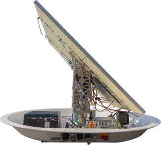
- Fast Set Up/Teardown: Single tool for mounting less than one (1) hour
- Field Maintenance: Made out of LRU parts for easy maintenance and repair
- MIL Standard Compliant: Easy handling
- Standard Shipping: Portable boxes shipped via FedEx, UPS, ...
- Designed for Field Operations: Air cooling free, auto North alignment, auto ground compensation

- Hardware Agnostic: Digitizer COTS Server
- LAN/WAN Resilient: Lossless transmission protocol network bandwidth reduction
- Multi-Mission: Radio validation, RF compatibility, in-orbit operations in LEO, MEO, GEO
- Cortex Hereitage, Cortex ICD and configuration management (CTX and MCS files)
- Ultra-High Data Rate and Storage Capacity: Up to 16 Gbit/s and up to 64 TB
- Advanced Data Capabilities: On-Board Data Analysis
- Extended Configuration Flexibility: User-Configuration Canister Concept
- Integrated Telemetry Outputs: IRIG 106 Chapter 7 Support
- Full Spectrum of Interfaces: 10GigE, Video, Fiber Channel, ARINC 429, PCM, MIL-STD-1553, H.265 Video, Analog…
- Cybersecurity: Data-At-Rest Capabilities (encryption key management), Removable Secure Operational Disk (for extraction of non-volatile memory from system)
- Designed for Orbit-Topping and Station Keeping
- 40% Weight Saving Convention Propulsion
- Excellent Thrust-to-Electrical Power Ratio
- Cost-Effective: Simple and Robust Mechanics provides High Performance with Limited Maintenance
- Auto & Slave Tracking: High Tracking Accuracy. Seamless User Interface as all SPARTE antennas. Option for Shipborne Operation.
- Transportable: Lightweight, Compact Antenna, Easy Setup
- Radome Protection: Against Rain, Sand, Dust… and no Sensitivity to Wind
- Applications: Ideal for Hypersonic, Missiles and Launch Vehicles Telemetry
Safran DSI
Safran DSI Testing & Telemetry provides complete, end-to-end solutions covering instrumentation, mission systems, onboard recording, and transmission, through to base stations for data monitoring and control. Our solutions are platform-agnostic and adaptable to customer mission needs.